Aviation

UAVs: Elevating Business, Empowering Visionaries.
Unlock the power of drones, UAVs, and autonomous aerial vehicles to revolutionize your operations. With over years of dedicated experience in the field, Bill brings unparalleled expertise to elevate your business to new heights.
Welcome to the Future of Aerial Innovation
UAV Solutions
From breathtaking aerial photography and videography to precise mapping and real-time construction progress monitoring, our UAV solutions offer a comprehensive range of services tailored to meet your specific needs. Document your assets with unparalleled accuracy, conduct pre-purchase inspections with confidence, and streamline insurance assessments with real-time visual information gathering.
We understand the importance of staying ahead in today's fast-paced world. That's why we empower you to build excitement and drive success with current and accurate visual information. Experience the difference with UAV Solutions and soar above the competition. Contact us today to elevate your operations like never before!


Below you can find the details of what goes into the licensed, professional piloting of UAVs.
Safety and security is priority number one. We take flight with great care and responsibility.
There are preflight and post flight requirements that must be followed to insure a project or mission is carried out correctly and legally.
FAA Part 107
Certificated Remote Pilot
In order to fly your drone under the FAA's Small UAS Rule (Part 107), you must obtain a Remote Pilot Certificate from the FAA. This certificate demonstrates that you understand the regulations, operating requirements, and procedures for safely flying drones.

Step 1: Learn the Rules
Step 2: Become an FAA-Certified Drone Pilot by Passing the Knowledge Test
Step 3: Register your Drone with the FAA
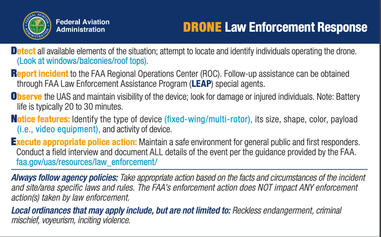
Public Safety Agencies, such as Law Enforcement, are in the best position to deter, detect, and investigate unauthorized or unsafe UAS operations. While drones can serve as a useful tool, these agencies also have an important role in protecting the public from unsafe and unauthorized drone operations. This information will help law enforcement and public safety professionals understand safe drone operations and their authority.
Handling Sightings and Reports
Federal Aviation Regulations prohibit the unsafe or unauthorized operation of an aircraft, including drones. Unsafe operations may result in substantial civil penalties and possible action against an operator's FAA-issued certificate, or may be subject to criminal response by law enforcement in accordance with Federal, State and local laws or ordinances. As a law enforcement officer, you are often in the best position to deter, detect and investigate unsafe or unauthorized drone operations.
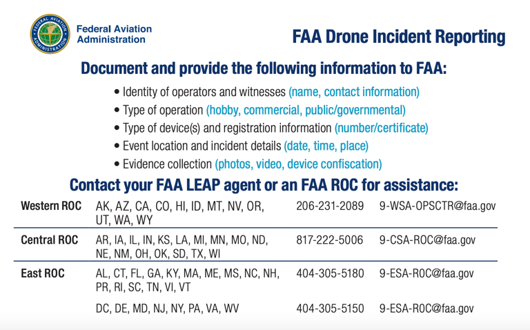

FAA Contacts for Law Enforcement
Special agents from the FAA's Law Enforcement Assistance Program (LEAP) are your point of contact for federal, state, local, tribal, territorial and international law enforcement agencies. LEAP special agents can provide information on drone enforcement and registration matters. Providing a LEAP special agent with reports of suspected unauthorized UAS incidents in a timely manner increases the FAA's ability to take enforcement action when appropriate. (NOTE: You may contact any LEAP agent if your assigned agent is not available.)
For further information on contacting a LEAP agent email us at UAShelp@faa.gov or call us at 844-FLY-MY-UA.
METAR and TAF
METARs (Meteorological Aerodrome Reports) and TAFs (Terminal Aerodrome Forecasts) are crucial weather reports provided by the FAA (Federal Aviation Administration) to ensure the safety and efficiency of aviation operations.
METAR (Meteorological Aerodrome Report):
METARs are routine weather reports issued by meteorological stations at airports around the world.
They contain essential meteorological data such as temperature, dew point, wind direction and speed, visibility, cloud cover, and present weather conditions.
METARs are typically issued hourly and are vital for pilots and air traffic controllers to assess current weather conditions at specific airports.
TAF (Terminal Aerodrome Forecast):
TAFs are weather forecasts specifically tailored for aviation purposes, focusing on conditions within a 5-nautical-mile radius of an airport.
These forecasts provide detailed information about expected weather conditions, including wind direction and speed, visibility, cloud cover, and any significant weather phenomena expected to occur within a specified time frame (usually 24 to 30 hours).
TAFs help pilots and aviation professionals plan flights and make informed decisions regarding departure times, routes, and potential weather-related hazards.
The National Weather Service (NWS) - Daily Brief
Both METARs and TAFs play a critical role in aviation safety by providing timely and accurate weather information, enabling pilots and aviation personnel to make informed decisions and mitigate risks associated with adverse weather conditions.
KSFO 240524Z 2406/2512 VRB05KT P6SM BKN250
FM250000 29005KT P6SM FEW250
FM250900 VRB03KT P6SM SCT250
TAF
KSFO 240556Z 00000KT 10SM FEW150 BKN180 14/08 A3007 RMK AO2 SLP182 T01390083 10183 20133 51003
METAR (below is a break down of character thread for KSFO)*
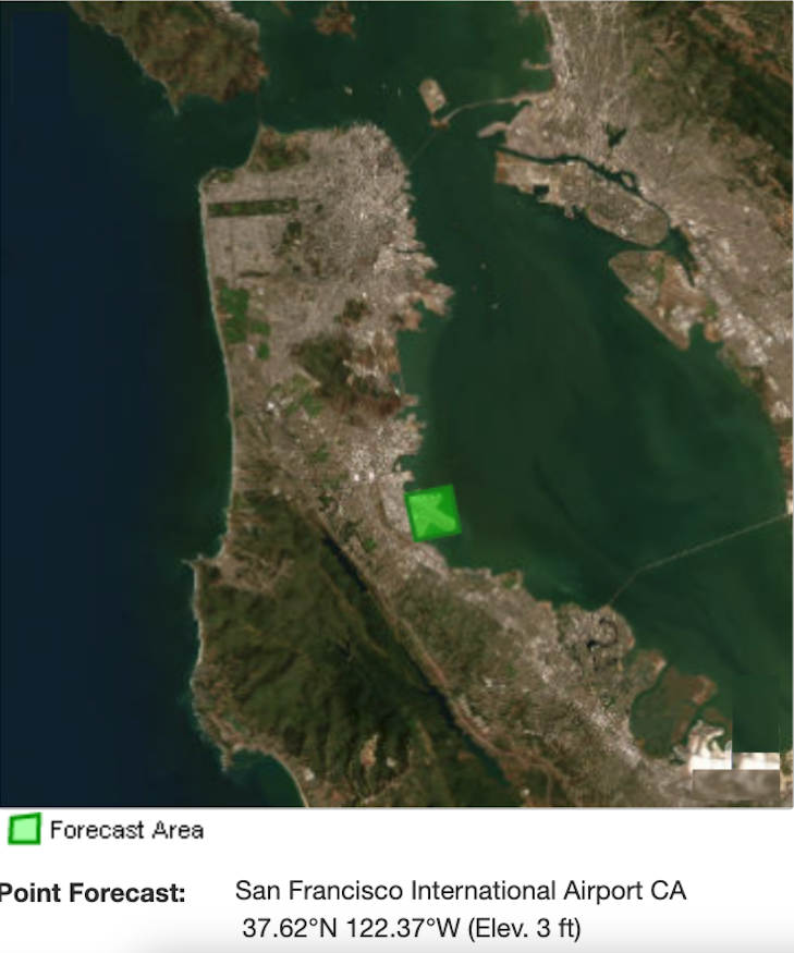
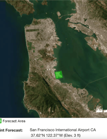
Example: Pilots Weather Information - Pre-Flight
METAR report for San Francisco International Airport (KSFO) provided:
Header Information:
METAR: Meteorological Aerodrome Report
KSFO: ICAO station code for San Francisco International Airport
240556Z: Date and time of the observation in UTC (24th day of the month at 0556 UTC)
Wind Information:
00000KT: Wind direction and speed
Wind direction: 000 degrees (calm, coming from the north)
Wind speed: 0 knots
Visibility:
10SM: Visibility
Visibility is 10 statute miles
Sky Conditions:
FEW150 BKN180: Sky condition
Few clouds at 15,000 feet above ground level
Broken clouds at 18,000 feet above ground level
Temperature and Dew Point:
14/08: Temperature and dew point
Temperature: 14°C
Dew point: 8°C
Altimeter Setting:
A3007: Altimeter setting
Pressure: 30.07 inches of mercury (Hg)
Remarks:
RMK AO2 SLP182 T01390083 10183 20133 51003: Additional remarks
AO2: Automated weather station with a precipitation sensor
SLP182: Sea-level pressure
T01390083: Temperature and dew point in tenths of degrees Celsius (13.9°C temperature, 8.3°C dew point)
10183: 1018.3 millibars, the atmospheric pressure at station level
20133: 201.3 millibars, the atmospheric pressure at sea level
51003: Automated weather station data quality (510 = OK, 03 = third cycle of the day)


